|
|||||
|
|
Impact of Massanjore Dam on hydro-geomorphological modification of Mayurakshi River,Eastern India |
|
| Authors: | Swades Pal |
| Affiliation: | 1.Department of Geography,University of Gour Banga,Malda,India |
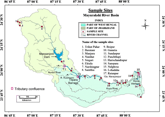
| Abstract: | Massanjore reservoir (area ~67 km2) located 84 km downstream from the most distant upstream source capacitates 620,000,000 m3 of water, and regulated flow characters are highly responsible for dam downstream alteration of hydrological, sedimentological and geomorphological characteristics of Mayurakshi River. In dam after condition, monsoon water level (mean water level during monsoon months) and pre-monsoon water level (mean water level during pre-monsoon months, i.e., March–May) have attenuated about 0.56 and 0.32 m, respectively. Maximum duration of high flow period during monsoon has reduced up to 16.5 %; coefficient of variation of diurnal fluctuation of water level during monsoon has increased from 31 to 47 %. Suspended sediment load in Mayurakshi River is reduced to 34 % in dam after period as recorded at Narayanpur gauge station. Average suspended sediment load has decreased even after Tilpara barrage construction from 4.960 to 4.350 mg/L. Average suspended sediment load is 7.875 mg/L in the sites of dam upstream course, and this average is only 4.46 mg/L in different sites of dam downstream course. Volume of discharge has decreased up to 11.3 % during monsoon time in dam after condition. Such reduction in discharge volume in turn has reduced about 24.6 % bed load-carrying capacity. As a result, huge deposition within channel invigorated channel bed aggradations (average 73.6 cm up to Saspara, site 14 at Fig. 1) in dam after condition. Narrowing of active channel, coarsening of channel bed materials, lowering of lateral stability, accelerating rise of braiding index, mixed response of the channel adjustment of the tributaries to local scale positive or negative base level change due to river bed aggradations and degradation, etc. signify the morphological alteration of dam downstream course. Fig. 1 Mayurakshi River basin indicating Massanjore Dam, Tilpara barrage and sample working sites |
| Keywords: | |
| 本文献已被 SpringerLink 等数据库收录! | |